- Abrasion (abrázió)
Wave erosion. The mechanical erosion of rocks caused by waves. In a broader sense, also rock destruction caused by running water, wind, and ice.
- Abrasion platform (abráziós terasz)
Sandy and pebbly seaward beach slope in front of a nip.
- Active layer (aktív réteg)
Top of permanently frozen (permafrost) areas, temporarily thawed, and saturated by water, where periglacial processes can be operate.
- Aeolian erosion (szélerózió)
The destructive activity of sand grains carried by the wind (corrasion).
- Aeolian transport (eolikus szállítás)
Depending on its energy, the wind can carry and move particles of rock. While dust-sized particles are moved high above the surface over long distances, the sand near the surface is by jumping (saltation) and small pebbles on the sand are moved by using sliding collision energy (reptation).
- Alluvial fan (hordalékkúp)
Flat, fan-shaped surface accumulation form that is deposited by the river waters in varying forms and sizes. Most commonly caused by the sudden decrease of stream gradient.
- Alluvial Plain (feltöltött síkság)
Flat areas supplied by rivers (fine plain). Undulating surfaces, loess plains, irregular moraine plains and sandy areas belong to this category as well. Some of them were generated following tectonic movements.
- Alluvial terrace (folyóterasz)
Surfaces accompanying the sides of river valleys as benches, parallel to water flow. The reason for their formation is a lasting, repeated change in the section style at the same place; thereby continuously widening sections replace each other, which leads to a gradual division of the sides of the valley.
- Alluvial terrace (hordalékterasz)
The remains of the valley of a meandering river. The channel incises into floodplain sediments (terrace flats) and creates terrace risers.
- Alpine-type forms
 (alpi formakincs)
 High mountains characterized by sharp ridges with jagged peaks caused by glaciation.
- Alveolar weathering (méhsejtszerkezet)
Special form of tafoni. The resistable ribs divides the surface of stone to many small, only few cm large, bubble-like hollows.
- Anastomosis (anasztomózis)
Channel splitting caused by avulsion. It is characterized by branches, long tributary streams around islands (e.g. the Amazon).
- Annular drainage (gyűrűs vízhálózat)
Drainage pattern typical of escarpments or upwarping.
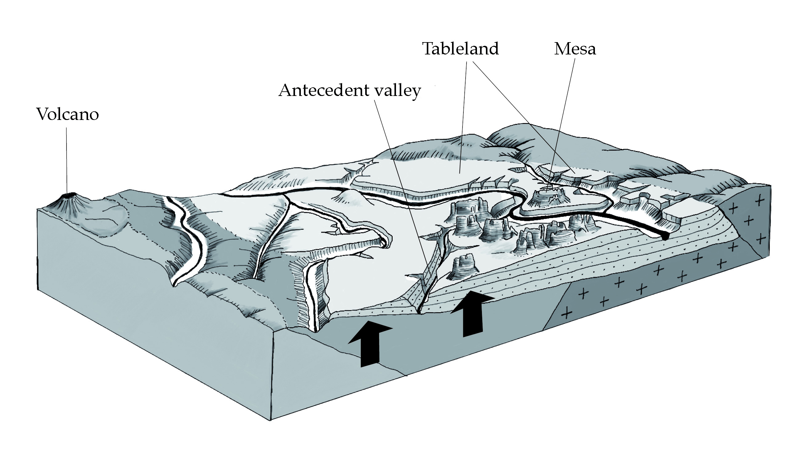
- Antecedent valley (antecedens völgy)
Cutting river valley remaining from the pre-uplift period, keeping pace with uplift.
- Anticlinal (redőboltozat)
The upper, arch-like part of the fold, formed during the deformation of the strata.
- Anticline (antiklinális)
Dome created by crustal folding.
- Appalachian structure (Appalache-szerkezet)
Heavily eroded landform consisting of parallel ridges and valleys.
- Arheic area (lefolyástalan terület)
Arid, land locked basins of the continents, where rivers do not reach the oceans.
- Arrete (kárgerinc)
Jagged, sharp alpine glacial form. Grooving out in the valleies of glaciated high mountains among the cirques.
- Atoll (atoll)
Ring of coral islands surrounding a 50-100 m deep lagoon, which may be cut through by smaller channels.
- Attrition (aprózódás)
Mechanical weathering when the rock disintegrates into smaller components.
- Avulsion (avulzió)
Displacement of river channel cutting through its bank and resulting in an anastomosing system.
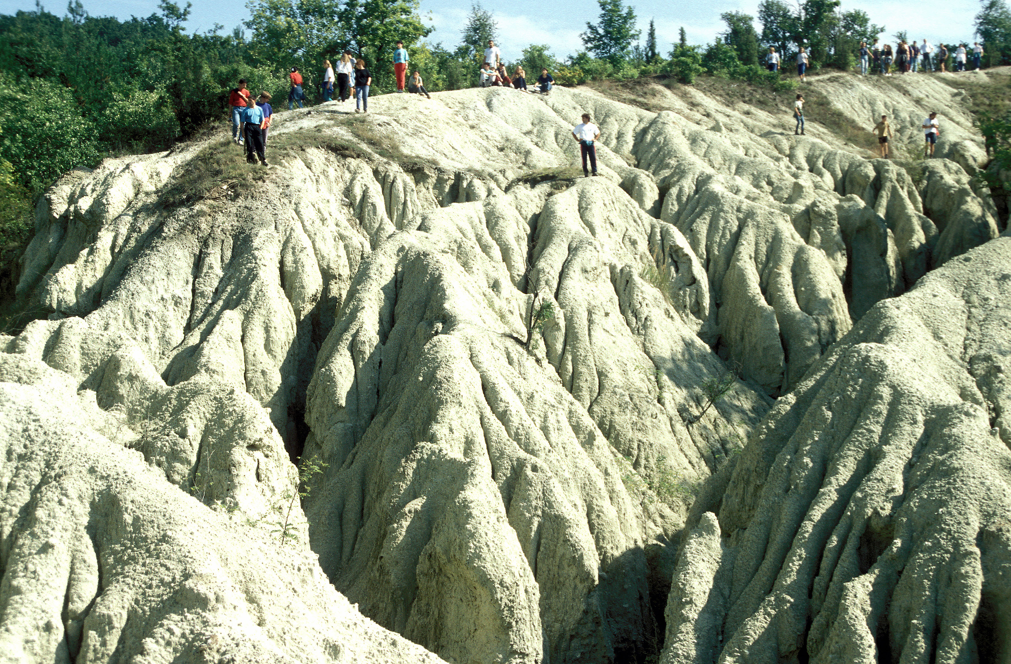
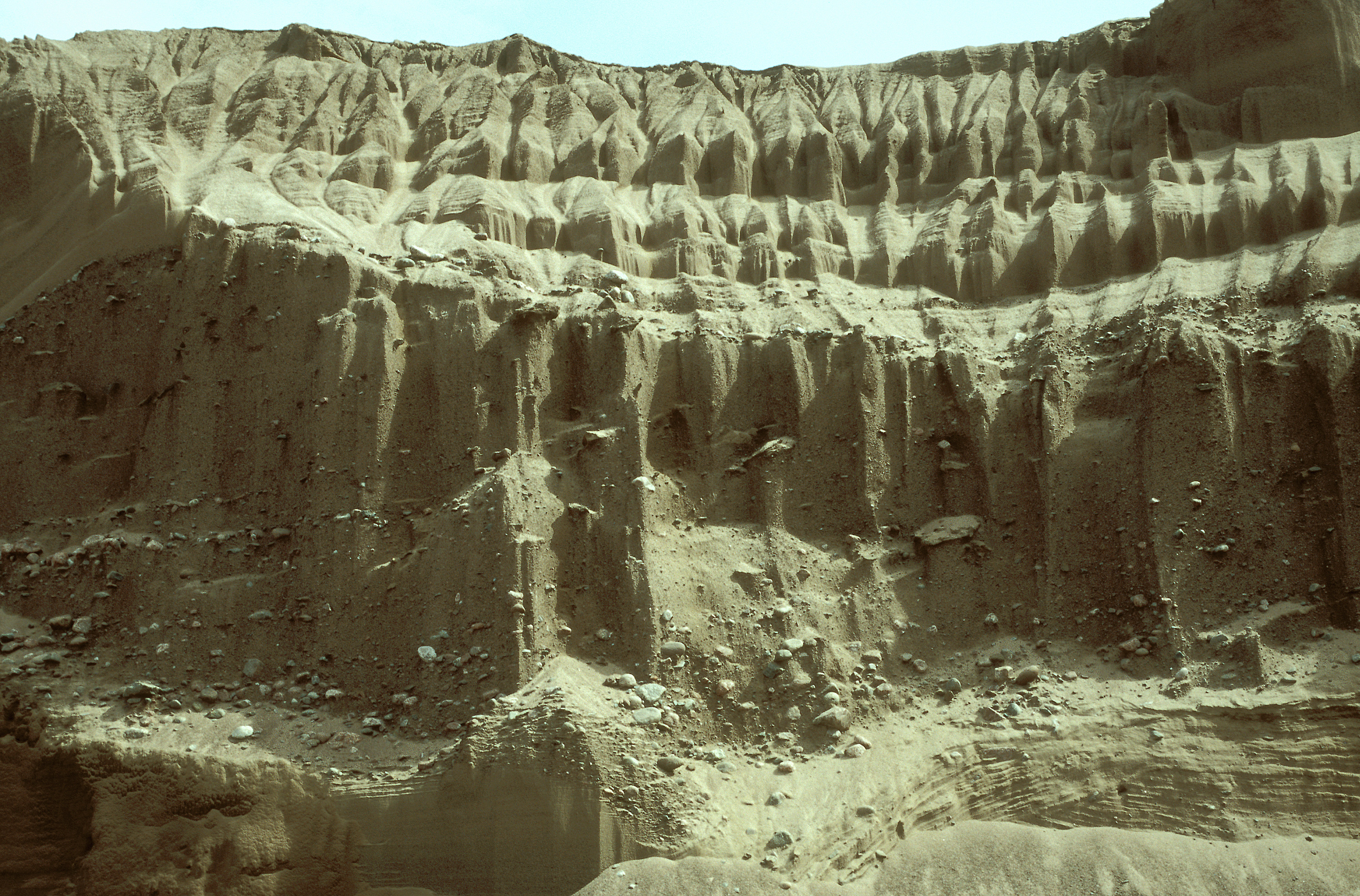
- Badland (felárkolt föld – “rossz föld”)
Strongly dissected surface. Under heavy precipitation bare surfaces of high relief, usually in loose sedimentary rocks, are strongly affected by sheet, rill and gully erosion as well as piping.
- Balancing (piedestal) rock (ingókő)
Unstable rock with very little support. Created by concentric weathering or delivered to its current location by ice (for instance: Velence Hills).
- Barchan (barkán)
Sand dune in the shape of a shield, half-moon or sickle, with horns against the wind direction.
- Barranco (barrankó)
Radial gullies and debris flows on the mantle of volcanic cones.
- Barrier reef (korallgát)
Formation of corals farther away from the shore which separated by a lagoon from the coast and can submerge under the sea at low tide.
- Base level of erosion (erózióbázis)
The level under which erosion is no longer able to work. The ultimate base level of erosion is usually the sea level. A trunk river is the local erosion base for its tributaries.
- Bay bar (rekesztőturzás)
Natural dam made of debris at the bay's gate, formed because of waves and backflow.
- Beach ridge (szegélyturzás)
Dam of debris, built by the waves directly at the shore. Between the beach ridge and coast there is no lagoon.
- Beheading of a river (folyólefejeződés – kaptúra)
It takes place where valley-heads and valley sections receding toward each other meet and the river regressing harder conquers the upper stream of the other.
- Biogenic attrition (biogén aprózódás)
Rocks disintegrating into smaller pieces for reasons of root growth and root acid solution effect.
- Bird-foot delta (madárláb delta)
Type of the river deltas, where an active river branch are more developped than others, and reach far out in the bay (or lake, or sea) (e.g. Mississippi river delta).
- Blind valley (vakvölgy)
Valley, ending (often in a sinkhole) at the rock boundary on the non-karstic surface bordering the limestone areas.
- Block (rög)
Between faults, if uplifted it is a horst, if subsided it is a graben.
- Block stream (kőfolyás)
Slow motion of material on debris cone or on slope and the created overground landform. This process is driven by daily temperature changes: the debris material expanding by the heat, later compress. When the rocks regain their original size they are somewhat displaced downslope.
- Bottom moraine (fenékmoréna)
Clay, sand, loam and sandy-marl sediment formed under one-time ice sheets.
- Braided channel (fonatos meder)
A river channel divided by mid-channel bars, with its thalweg split but still considered a single bed.
- Branched (dendritic) drainage (ágas vízhálózat)
Branched (dendritic) drainage (ágas vízhálózat).
- Breakers (hullámtörés)
In shallow water at reefs, close to islands, sea cliffs or headlands the speed of the waves reduces and also their direction changes. The previously uniform crest of the wave bends, because in shallow water the waves slow down more suddenly than in deep water.
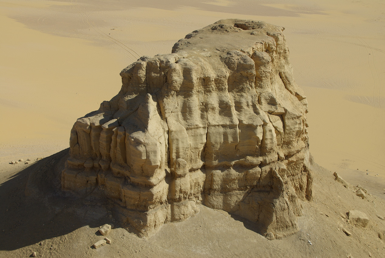
- Butte (tanúhegy)
A hill with steep sides isolated from its environment, reflecting the original altitude of the surface. The isolation is the result of the different rock qualities. It is a characteristic formation of the semi-arid regions. In Hungary, the basalt-capped buttes in the Tapolca Basin serve as examples.
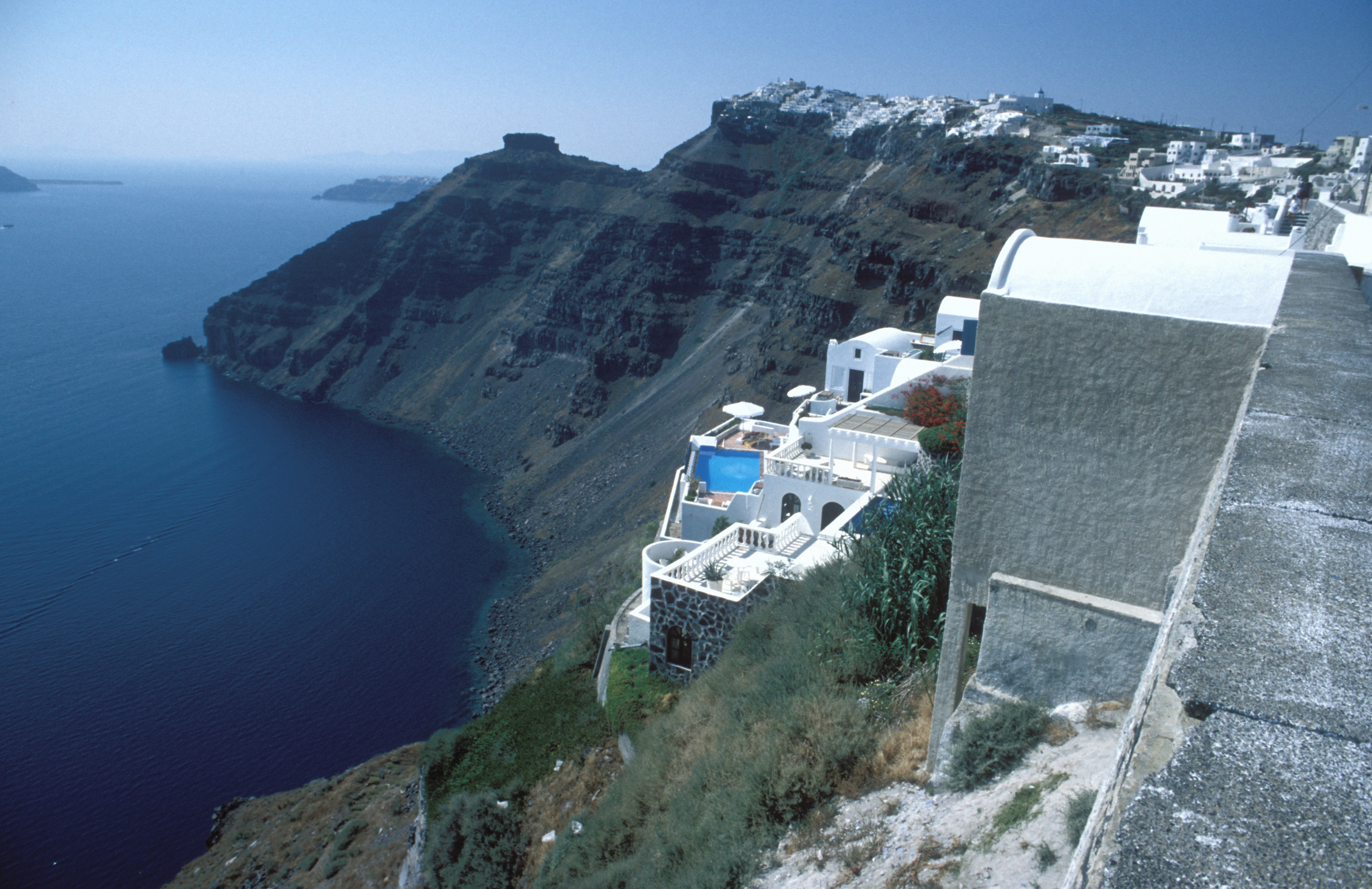
- Caldera (kaldera)
A caldron-like depression on the top of the volcano (up to 15-20 kilometers of diameter, the depth is approx. 700-800 meters). Formed by explosion, collapse or denudation (erosion) (e.g. Volcano island and Santorini).
- Caliche (caliche)
Latin American name used for calcrete.
- Calving (borjadzás)
A process when glacial -ice reaches the sea and, due to the buoyancy, pieces of various size are detached from it forming icebergs.
- Cave (barlang)
Cavity accessible by man and formed naturally in Earth's solid crust most often due to limestone dissolution and erosion (e.g. Baradla Cave, Aggtelek Karst, Hungary).
- Cenote (cenote)
Water-filled, steep-walled karst depression of the Yucatán Peninsula (Mexico).
- Centripetal drainage (centripetális vízhálózat)
In closed basins (calderas), a water network developing on the inner side with streams moving radially on the interior slopes.
- Channel erosion (árkos erózió)
A rapid and catastrophic type of erosion which creates furrows in channel.
- Cinder cone (Salakkúp)
Small volcanos with steep (25–30°) slopes, composed of vulcanic slag and ash, formed be the explosive volcanism.
- Cirque (cirkuszvölgy)
Semi-circular, steep-walled basin with firnification. The location of glacier formation and with some glacier -types an area of ice accumulation. It is formed in the leeward valley heads of high mountains with snow cover.
- Cirque (kárfülke)
Snow,- and ice-eroded depression extended by frost shattering, spoon-shaped alpine form.
- Cliff (sziklafal)
Near-vertical, or at least 40° steep terrain.
- Concave slope (homorú lejtő)
Slope shape typical of dry regions. The upper section is the steepest.
- Constraint forms (kényszerformák)
Sandforms which will be formed by the wind on the leeside of bush, rocks or lonely hills (tied dunes).
- Convex slope (domború lejtő)
A slope type generated by strong sheet wash. It is the steepest at the bottom.
- Corrosion (korrózió)
Chemical decomposition, occured by the solutional effect of the water infiltrating into the rock.
- Craton (ősmasszívum)
Old, crystallized, solid and inflexible part of the Earth's crust, which is often a peneplane (e.g. Baltic and Canadian craton).
- Cryogenic attrition (fagy okozta aprózódás)
The attrition process concerning the largest area. It is caused by freeze-thaw alternation due to temperature fluctuation, i.e. the freezing and melting of ice in the joints.
- Cryoplanation (krioplanáció)
Planation of surface caused by frost. Various levels on mountains and hills the frost can smooth the surface.
- Cryoturbation (krioturbáció – fagyörvénylés)
Deformation os soil-layers caused by frost. The possible forms of the deformation are waves, columns and amorphous.
- Cuspate spit (turzáskampó)
A type of spits forming parallel to the shore. Where the direction of the coastline changes, it continues to grow in the original direction due to the longshore drift but then it starts to curve towards the coastline.
- Debris cone (törmelékkúp)
Debris eroded down from cliffs and steep slopes and deposited in a fan-shaped manner at the base of slopes. Through the merging of debris cones debris slopes are formed.
- Deep oceanic trench (mélytengeri árok)
Deep and long trench with steep walls, formed in the subduction zones of the oceanic tectonic plates. This trenches are the deepest places of the World Ocean (max. depth 11 km).
- Deflation (defláció – kifúvás)
Wind activity carrying loosened rock material.
- Deflation basin (deflációs medence)
Basin-shaped depression formed as a result of deflation.
- Delta estuary (delta torkolat)
Deposition on estuarine coasts by rivers carrying a lot of silt where neither the tide nor wave action is significant.
- Derasion (derázió – lejtőmarás)
Slow mass movements and flows shaping slopes.
- Derasion valley (deráziós völgy)
Low gradient, bowl or half-cylinder shaped, longitudinal valleys hilly and highland areas, predominantly formed by soil creep and streams especially in periglacial climate during the Pleistocene.
- Doline (dolina – töbör)
Closed, rounded surface karst depressions. Its diameter and depth may range from a few meters to several hundred meters.
- Dripstone (cseppkő)
Limestone, most commonly precipitated as calcite from water rich in dissolved carbonates in karst cavities (caves). Stalactite curtains hanging from the ceiling of caves are long and often wavy formations. A stalactite column in a cave is the manifestation of adhesion between a hanging condensation (stalactite) and a ‘candle’ growing upwards (stalagmite).
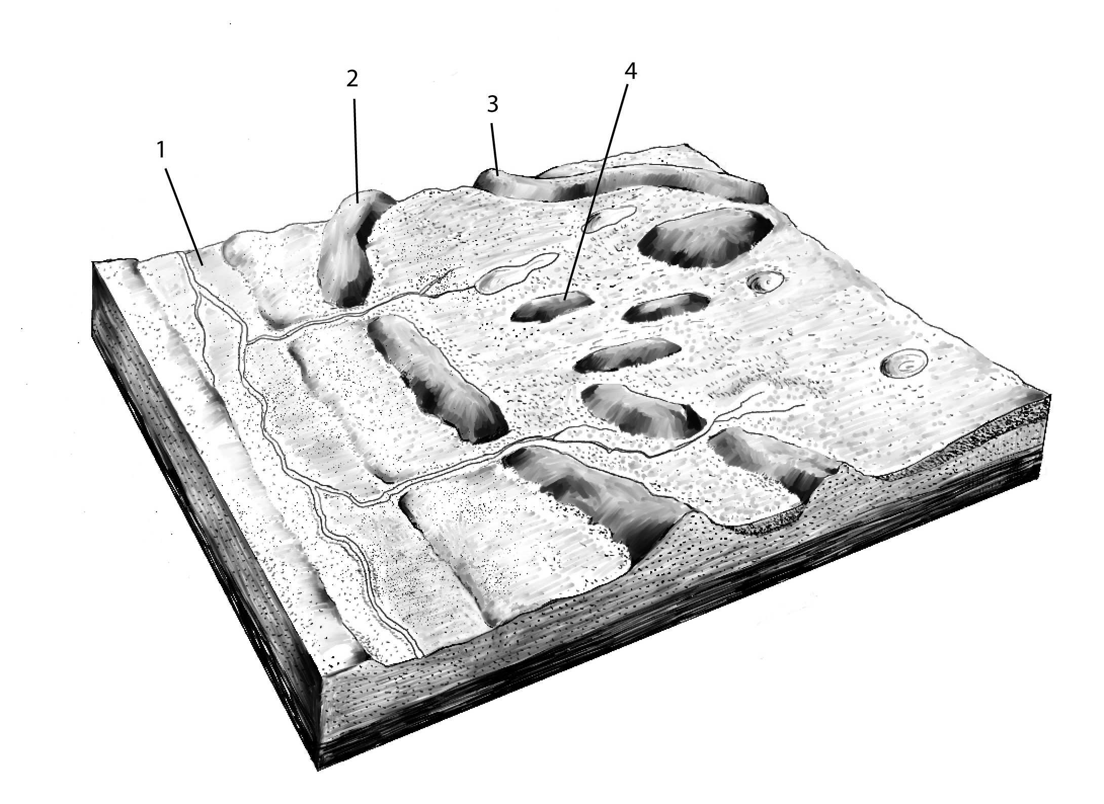
- Drumlin (drumlin)
Streamlined, teardrop-shaped moraine hill in areas once covered with ice.
Figure 2.11. Generalized block diagram of subglacial landforms 1 = glacial spillway, 2 = terminal moraine, 3 = esker, 4 = drumlin
- Ephemeral drainage (efemer vízfolyás)
Type of temporary streams. It supplies water only for a few days following rainstorms.
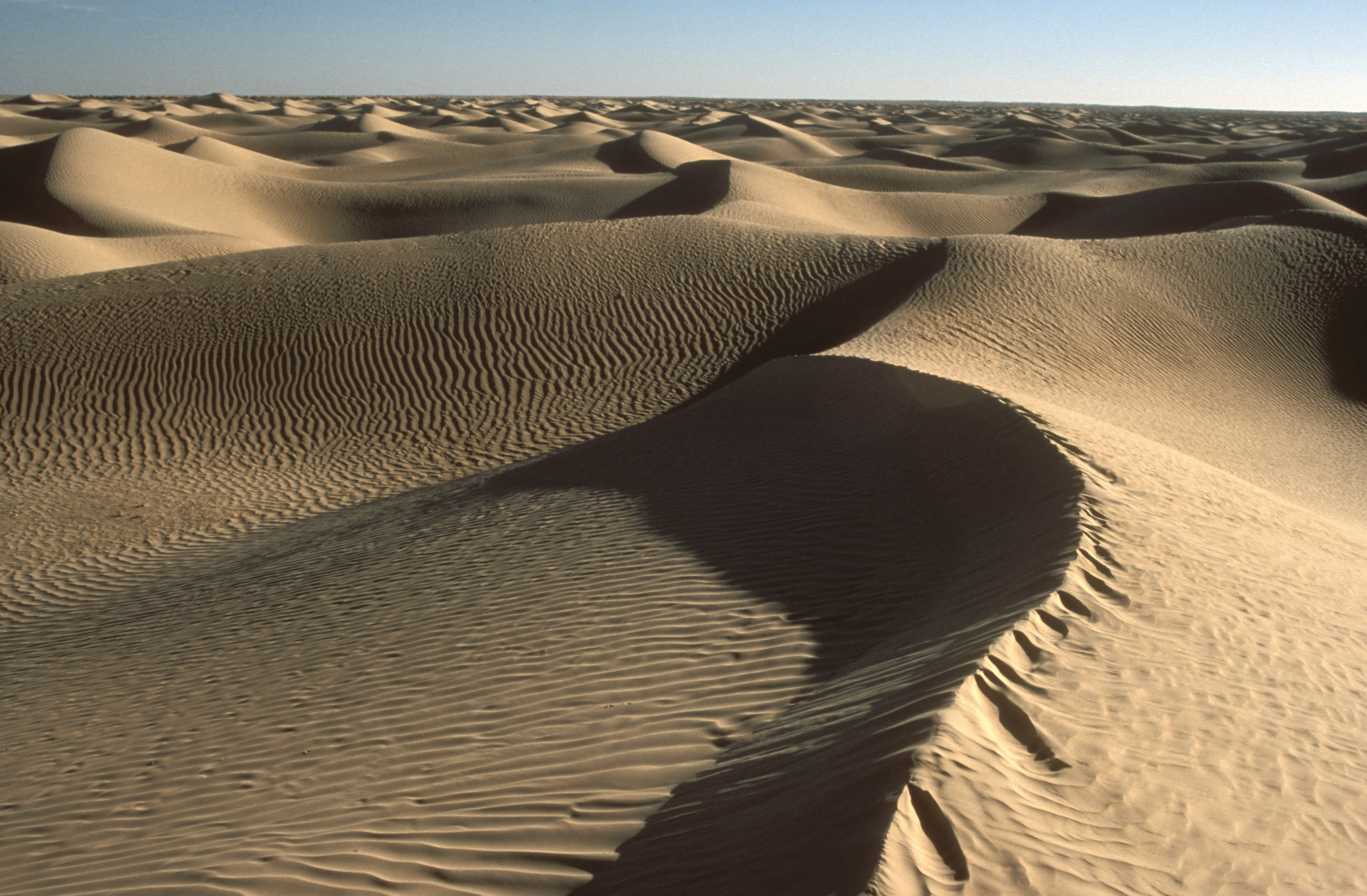
- Erg (erg – homoksivatag)
Local name for sand desert in the Sahara.
- Erratic block (erratikus blokk – vándorkő)
A large piece of rock moved far away by a domestic ice-cap.
- Esker (óz)
Subglacial form composed by sediments, shaped under pressure in icetunnels by the meltwaters. The few km long, billowy ridge composed by sand, gravel and silt, lengths from 10 meters to few kilometers. The elevation of eskers can reach 10-50 m, their width 50-200 m.
- Estuary (tölcsértorkolat)
Coastlines exposed to strong wave action and tides the mouths of rivers broaden out and deepen(like a funnel) (e.g. Elba River, St. Lawrence River).
- Evorsion pothole (evorziós üst)
A cauldron-shaped cavity formed by rotating water with or without the help of transported load.
- Firn (csonthó)
Ice-grains formed as a result of multiple melting and re-freezing of snow accumulation in high mountains.
- Firth (fjord)
A deep, U-shaped valley carved through by glaciers of the ice age on a coast. With the ice melting, the sea spread over this valley.
- Flood plain (ártéri lapály)
The farthest and lowest parts of the flood basin, where flooding brings only the finest silt and clay deposited in a horizontal sheet stratification.
- Free sandforms (szabad homokformák)
Forms of the sand in areas where the sand can move freely. The linear, and longitudinal dunes, the barchan or the pyramid shaped dunes are free sandforms.
- Frost wedge (jégék)
During the winter months, the water in the ground freezes and expands. Once temperatures reach -17 degrees Celsius or lower, the ice that has already formed acts like a solid and expands to form cracks in the surface known as ice wedges. As this process continues over many years, ice wedges can grow up to the size of a swimming pool.
- Gelisolifluction (geliszoliflukció)
Large-scale, frozen soil displacement over whole hillsides in motion.
- Geomorphology (geomorfológia – felszínalaktan)
Earth science dealing with the description, organization and formative processes of the Earth's surface forms. It is on the border of geology and geography.
- Glacial valley (gleccservögy)
A U-shaped or parabolic valley as transformed by ice of earlier river valleys in high mountains.
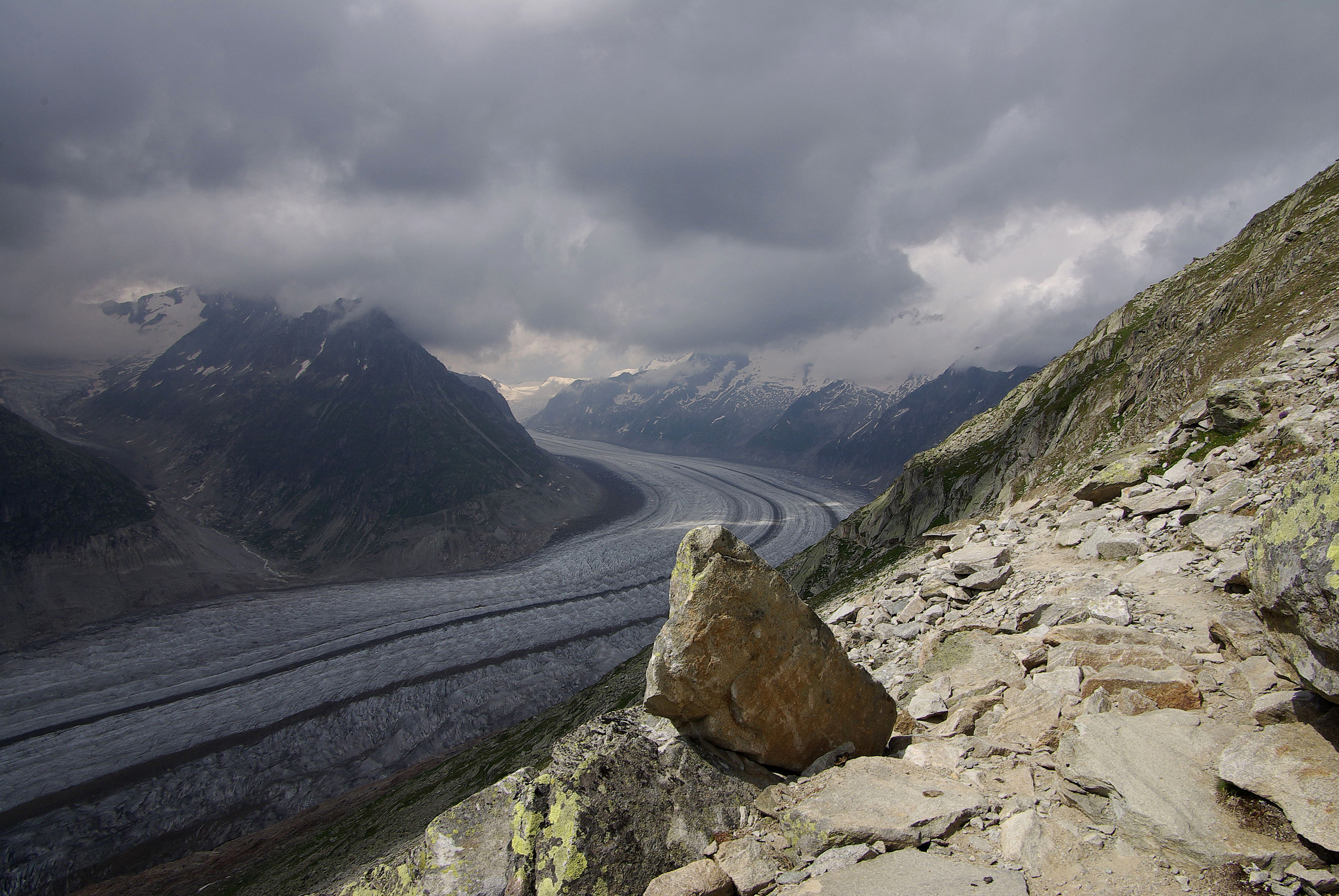
- Glacier (gleccser)
Massive ice-flow progressing in a well-defined channel, moving toward a glacial slope. Its different forms are cirque glacier, glacier -network, boundary -glacier, valley -glacier and piedmont -glacier (e.g. Aletsch Glacier, Switzerland).
- Gully erosion (árkos erózió)
Erosion by rills, gullies and gorges forming from the dissection of the water film when runoff waters collect.
- Guyot (guyot)
Ocean-floor mountain of volcanic origin trimmed by the waves of the sea.
- Hammada (hammada – kő- és sziklasivatag)
Rock and stone deserts. Coarse blocks of residual cover in the Sahara.
- Hanging valley (függővölgy)
Following the melting of glaciers, smaller side-valleys join the deeply carved, U-shaped main valley well above its bottom and their streams pour down as high waterfalls.
- Headwall (homlokfal)
The very steep back wall of a cirque.
- Highland (fennsík)
A plain which is more than 200 meters high above sea level, usually related to mountains (e.g. Andes highlands – Altiplanos).
- Hill (dombság)
Low (90-300 m) surface elevation.
- Hogback (rétegborda)
Ridge or terrain step, formed in steep and hard stratas of the upturning rock. Not so asymmetric as the kuesta.
- Horn (kárpiramis)
The jagged, sawtooth-like ridges, usually ending in sharp peaks (such as Matterhorn, Alps).
- Horst (sasbérc)
It’s a crust, that is risen from its enviroment, along faults (for instance: Naszály).
- Hydration (hidratáció)
Some minerals (for example: the anhydride, clay-minerals) have the ability of binding water on their surfaces. This is the first step to dissolve minerals in water.
- Ice Sheet (belföldi jégtakaró)
More or less independent of the geological-structure of its surroundings, in every direction expanding massive mass of ice. The continental ice sheets are large (several million square kilometers), the average thickness is more than 2000 meters (for instance: Antarctica, Greenland).
- Inflection Line (inflexiós vonal)
The separation line of the convex and concave slope segments, in reality it is a zone, where the slope is steepest.
- Insolation weathering (inszolációs aprózódás)
Different degrees of expansion and contraction of the material caused by temperature variations leading to rock fragmentation.
- Intermittent Stream (időszakos vízfolyás)
Mainly associated with arid and semiarid areas. A stream which carries water a considerable portion of the time, but which ceases to flow occasionally or seasonally because bed seepage and evapotranspiration exceed the available water supply.
- Inversion (inverzió)
The erosion-material of once, higher positioned landscapes filling up lower lying area. Another example: lava flow from a volcanic crater fills up the valley and so protects the valley. In this case, with the destructing volcanic mountain denudation follows, but the surface around, covered by flood lava is preserved.
- Kame (kame)
A small hill or ridge consisting of layers of sand and gravel deposited by a meltwater stream along the margin of a melting glacier.
- Karren (karr)
Surface karst form. On the bare rock surfaces small, few cm long groves are formed, or under the soil small basins are created. Later their depth can reach even one meter.
- Karst features (karsztformák)
Group of under- and overground forms (karren, dolinas, poljes, uvalas and caves) can formed in easily slouble or in strongly ripped material of limestone mountains.
- Kettle (Soll) (olvadéktó)
The lagging iceblocks of the receding ice sheet is overlain by deposits from the melting ice. After the complete melting of the ice only a round lake remains.
- Lagoon (lagúna)
Waterbody lying between the coast and bars. The lagoon will be slowly filled up and will loose its salinity. The lagoon refers to the central, water filled area of the atolls too.
- Lahar (iszapár)
An unstable flowing mass on the volcano slopes. Consists of volcanic dust and debris mixed with water.
- Landform (felszínforma)
Elements of the topography of the Earth. Grouped by size: large structural forms (e.g. a mountain range), smaller is the macro-form (e.g. a mountain), meso form (e.g. on a mountain side) and micro form (e.g. a water flow).
- Lateral moraine (oldalmoréna)
Till melting out from the ice at the edge of glacier. The till is transported on by the moving ice.
- Levee (folyóhát)
Low-lying natural dam rising above the river bank on one side with a gentle slope on the other. At times of flood, levees are built along the river bed where the roughest deposit is drifted.
- Loess mantle (lösztakaró)
Standable, sedimental stone, composed by very small (0,02 – 0,05 mm diameter), wind transported, sleazy structured granules. The world's largest loesses mantles were formed in China along the Yellow river and in the Carpathian Basin, in Mezőföld.
- Marginal coral (szegélykorallok)
Coral atolls located directly on the shore.
- Marine ice (tengeri jég)
Due to its salt content sea water freezes only below 0°C. The insulating effect of the ice prevents heat loss of the underlying sea water, therefore marine ice can thicken only at a slow pace. Its average thickness is rarely more than 3 metres (however, the thickness of the splitted up and piled up ice masses can reach up to 20-30 meters).
- Mass movement (tömegmozgás)
Surface-forming processes which are a direct result of gravitation, and operate without a transportation medium.
- Meandering river (meanderező folyó)
The river with middle reaches characteristic creates meanders on its own floodplain. The outer side of the meander bend will be continuously eroded by the river, on the inner side there is accumulation. If the neck of the meander will be cut by the river, then the meander turns into an oxbow lake.
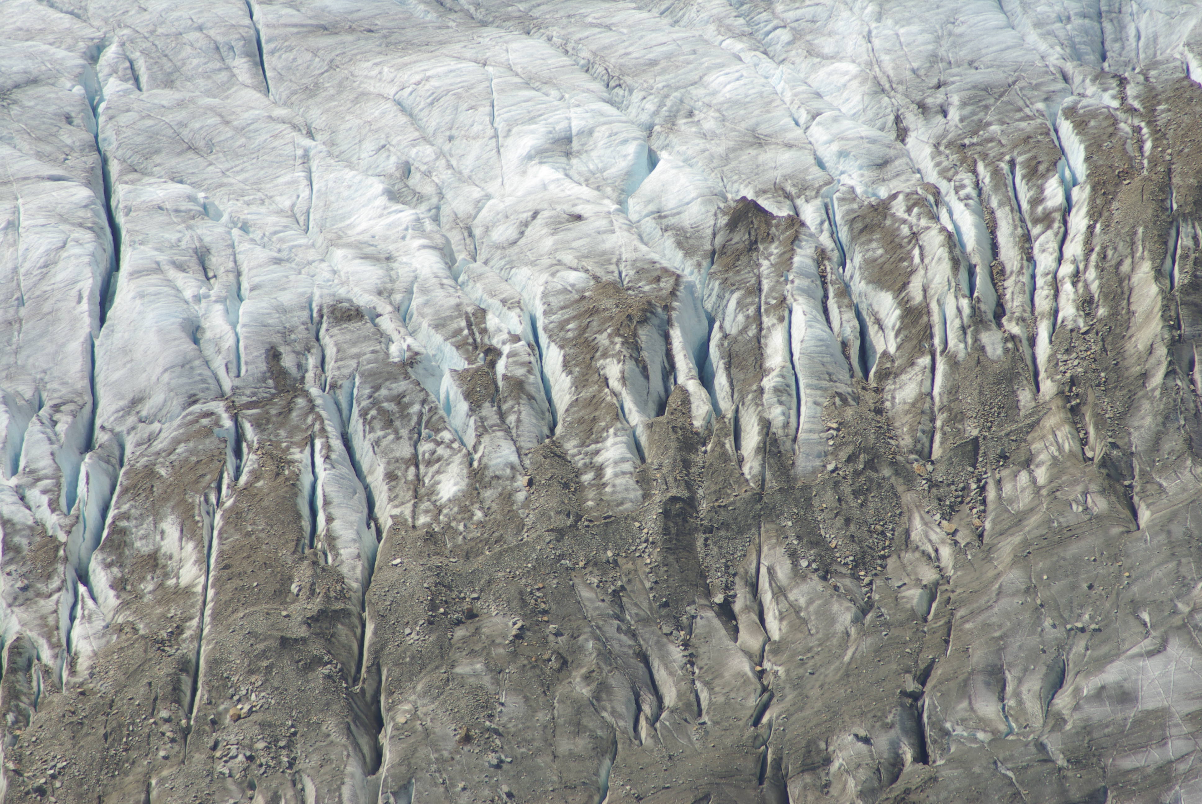
- Medial moraine (középmoréna)
Dark coloured stripe of sediments in the midline of a glacier, which establish from lateral moraine after the confluence of glaciers.
- Mesa (meza)
Tipical landform of the arid and semi-arid areas. This single standing hill has a flat summit, surrounded by steep slopes. The mesa contains horizontal beds, the upper beds are harder than the softer beds below.
- Mid-channel bar (mederközépi zátony)
Cross-bedded alluvium on the bottom of midle line in a braided channel. These are dynamic phenomens, the shape changes after every flood.
- Mid-oceanic ridge (óceánközépi-hátság)
Peripheral elevation at the developing edges of the oceanic tectonic plates. The ridges are uplifted by the basalt rising from the mantle.
- Mountain (hegység)
A part of the earth's surface, that mostly consists of mountains, valleys, basins (rarely plateaus), and straddled valleys, distinct from the surrounding basins landscapes. Based on their height low, (usually 400-600 m), medium (600-1500 m) and (above 1500 m) highmountains are distinguished. Their development (or structure) may be volcanic, folded and faulted mountains.
- Nip (abráziós fülke)
A long, semicircular groove in beach rocks carved by wave erosion.
- Nivation (hóerózió)
The erosional effect of temporary or permanent snow patches and also of firn, which increases the frost-shattering.
- Nivation (hófolterózió)
Erosion by temporary or permanent snowpatches and firn, which can enhance the frost occured errosion.
- Normal slope (normális lejtő)
Complex form of the slopes, on the top convex, at the bottom concave shaped.
- Nunatak (nunatak)
Ice-free summit of the mountains standing over an ice sheet.
- Outwash plain (olvadékvíz-síkság)
Plain around ice sheets, formed by sediments washed out from the melting ice and transported by meltwater.
- Overflow channel (ősfolyamvölgy)
In the Quaternary the northbound rivers were diverted by the expanding ice sheets. The rivers formed wide valleys collecting meltwater too.
- Oxbow lake (morotva)
Inactive river meander, cut from the river by natural processes or by anthropogen activites (e.g. Mártély oxbow lake).
- Palsa (palsa)
Torf-hill with ice core in periglacial areas.
- Parabolic dune (parabolabucka)
Aeolian landform of partially stabilized sand areas. Horns point against the wind direction. The wind blows sand out from an oval blowout depression downwind and and to the sides (like in the Nyírség).
- Pediment (hegylábfelszín)
Results of intensive erosion. Created by the receding mountain front . A broad, and very slightly sloping surface of fragmented rocks.
- Peneplain (elegyengetett felszín)
Larger, slightly sculpted, slightly undulating surfaces evolving through.
- Periglacial forms (jégkörnyéki formák)
Areas of frost action particularly occurring in the fringe areas immediately surrounding the great continental ice sheets of the geologic ice ages, with respect to environment, topography, areas, processes, and conditions influenced by the low temperature of the ice.
- Periglacial forms (periglaciális formák)
Specific forms of the arctic and mountain regions, lying above the timberline of the mountains and northward from the arcic tree-line. The forms were covered by arctic lithosols. In the development of the surface frost action is predominant.
- Pingo (pingó – domb)
Ice-cored hills, groowing from the supercooled groundwater. The squeezed groundwater freeze under the surface and built a hill.
- Piping (suffosion) (alagosodás)
Cavity formation inside loose, mostly sedimentary rock masses due to quick water infiltration. Underground tunnels formed by erosion continue to grow by slumping. In their development rodents, rabbits or tree root cavities can play a role as well.
- Plain (síkság)
Almost horizontal surface, where the vertical difference between two points is not more the 200 meters. If the relief does not reach 30 m it is a flat plain. If the fifference of elevation is between 30 and 200 m it is an undulating plain. A plain can be formed by accumulation or by denudation.
- Playa (playa)
American name of clay pans.
- Point bar (övzátony)
Cross-bedded, parallel bars of sediment, formed by the rivers at the inner side of bends.
- Polje (polje)
Closed surface form of the karst areas with steep sidewalls and flat bottom. The polje has a karst drainage.
- Ponor (víznyelő)
Chimney-like, moostly vertical caves of the karst areas.
- Radial drainage (sugaras vízhálózat)
Radially oriented valleys on volcanic mountains.
- Raindrop erosion (csepperózió)
Devastating effect of raindrops hitting on bare soil surface. It can be separated into two phases: impact and splash.
- Regolith (málladéktakaró)
Surface layer, originated from the primary weathering of rocks.
- Regression (regresszió)
Backward cutting erosion activity of the rivers.
- Ria bank (riapart)
Formed on submerging coasts, where the ridge of mountains are perpendicular to the coastline, and V-shaped or soled V-shaped walleys will be flooded by the sea.
- Ripple mark (homokfodor)
The smallest (only few cm high), to wind direction perpendicular, accumulation of sand - minor ridges on the surface of sand. Their cross section is asymmetric: the windward slope is 10 degrees and 30-35 degrees at the leeward side.
- Rock slide (kőzetcsuszamlás)
The most rapid and humid form of gravity mass movements. For its generation a slant and wet impervious layer (e.g. clay) which acts as a slip plane is needed.
- Rockfall (kőzetomlás)
Freefall or rolling of rocks, caused by earthquake or exogenic processes.
- Saltation (szaltáció)
Bouncing movement of the sediment on ballistic trajectory by wind or water.
- Sand dune (homokbucka)
Landforms created by aeolian accumulation, appearing isolated or in groups.
- Sand splay (homokfolt)
A small alluvial fan or other outspread deposit formed for example in case of big floods, where an overloaded stream breaks through a levee and deposits its material (often coarse-grained) on the floodplain. Also known as channel splay.
- Scrolling (görgetés)
The movement of bedload along the bottom of a river bed.
- Seamount (tenger alatti hegy)
The cones of submarine volcanoes are the most striking elements of the topography of oceanic plains.
- Seif dune (hosszanti dűne)
Aeolian landforms in the direction of the wind, with sharp, curved crests. They are classified into the group of major desert landforms. Their lengths can exceed several tens of kilometers, the height of 100 meters.
- Semi-coherent sand forms (félig kötött homokformák)
Sand forms, in the development of which wind conditions and the role of vegetation are essential (e.g. blowout dunes – Nyírség).
- Serir (reg) (kavicssivatag)
Name of pebbly and stony deserts in the East Sahara. In the Western Sahara they are called regs.
- Sheet erosion (felületi erózió)
The washing of fine surface material in mild slope conditions.
- Sheet wash (felszínleöblítés)
Runoff caused by water shroud evenly distributed on the surface.
- Shelf (kontinentális talapzat)
Part of the continental crust, covered by the sea. The depth of the water is not more than 200 meters.
- Shield volcano (pajzsvulkán)
Wide-area vulcano with slight slopes, composed mainly from basalt. The basalt breaks through, slowly, calmly on more craters to the surface (e.g. Mauna Loa, Hawaii).
- Shore dune (parti dűne)
Ridge of dunes parallel to the seashore. The dry sand of the shore will be transported by the wind to the land.
- Slab landslide (szeletes csuszamlás)
Mass movement where the slip plane outcrops at the base. The moveing material is cut into slabs by curved ruptures.
- Slide (slip) (csuszamlás)
Mass movement on a slope consisting of horizontal movement and the dipping of a sliding mass.
- Slope (lejtő)
Main element of the relief. Every surface is a slope, with some angle to the horizon.
- Slump (karéjos csuszamlás)
A form of mass movement where rock and soil move downwards along a concave slip plane. The rock or soil rotates backwards as it moves in a rotational slip. Slumps are most common in thick regoliths and large mudstone rock units, but can also occur in hard rock which has been shattered. They differ from slides because they always have shear planes which are concave, while the latter have relatively straight shear planes.
- Slump (suvadás)
Rotating type of mass movement. It can be observed mainly in loess.
- Soil creep (talajfolyás – szoliflukció)
Slow motion of water filled soils on slightly sloping surfaces. Under temperate climate conditions soil creep can occur mainly in the late winter melting period, and after intensive summer rainfall events.
- Soog (backrush) (tengervíz visszaáramlás)
Backflow of the wave's water into the sea.
- Stack (abráziós torony)
Rock formed on an abrasion platform as a result of selective decay by wave erosion- and often by arc collapse (e.g. Faraglioni rocks, Aeolian Islands).
- Stalactite (függő cseppkő)
A type of dripstones growing down from the ceiling of karstic caverns (caves) by deposition from water rich in dissolved carbonates.
- Stalagmite (álló cseppkő)
A type of dripstones with rounded tips growing upwards from the floor of caves.
Figure 2.24. Stalagmite in the Mulu National Park, Borneo, Eastern Malaysia [photo by Zoltán Karancsi]

- Star dune (Ghourd) (csillagdűne)
Pyramid-shaped, vertically developing sand dune with a ‘backbone’ like a star.
- Stratovolcano (rétegvulkán)
Mixed type of the volcanos. In one stage of the eruption lava coming from the crater, later falling volcanic debris. This dual activity results in a stratovulcano.
- Structural form (nagyszerkezeti forma)
Large scale type of landforms (like mountain belts, plateau or plain).
- Structural geomorphology (szerkezeti geomorfológia)
A morphological discipline studying the tectonic processes forming the mega-tectonic units of lands/terrains (continents), and the effects of structure and rock quality.
- Structural trench (szerkezeti árok)
Narrow depression, which sat down through subsided along longitudinal fracture lines (e.g. East-African trench).
- Submarine valley (tenger alatti völgy)
Sunken, incised river valley found in continental shelves covered by shallow sea (e.g. in case of Congo River, Mississippi River).
- Syncline (redőteknő)
The lower part of the fold, formed during the deformation of the strata.
- Tableland (táblás vidék)
A plain built up of the flat structural surfaces of roughly horizontally stratified sedimentary rocks. It is not affected by folding and is lifted to its current altitude by movement along fault-lines (faulting).
Figure 2.26. Mesa in the Libyan Desert: Wadi el Rayan near the Faiyum Oasis [photo by Zoltán Karancsi]
- Tafoni (tafoni)
A special cavity in rocks believed to be formed by salt weathering and weathering processes caused by water vapour.
- Tarn (kártó)
A type of lake formed in a cirque after the melting of the ice (e.g. Zenoga Lake, Retezat).
- Terminal moraine (végmoréna)
A type of moraines deposited at the terminus of the glacier or ice sheet.
- Till (moréna)
Non classified and non stratified alluvium, transported by ice.
Figure 2.28. Terminal moraine sequence exposed by a quarry, Southern Finland [photo by Zoltán Karancsi]
- Tombolo bar (tomboló)
A usually curved pair of sand bars which join an offshore island with the mainland.
- Transversal dune (keresztirányú dűne)
Free-moving sand form, perpendicular to the main wind direction. To built it significant amount of sand recharge is needed.
- Tropical peneplain (trópusi tönkfelszín)
An undulating surface of erosion with dome-shaped residual hills, known as monadnocks (or inselbergs). It is formed under tropical climate by rapid and uneven denudation. In a dry period the physical weathering, while in a wet period the chemical weathering erodes the surface.
- Trough valley (gleccservölgy)
U- or parabola-shaped valleys, which were formed by the glacial transformation of the former river valleys in the high mountains.
- Turbidity current (zagyár)
The rapid slumping of loose sediment on a steep slope due to oversaturation. During its movement sediments of different grain sizes get mixed up in it. If its matrix is volcanic ash, it is called lahar.
- Uvala (uvala)
Large, elongated karstic sinkhole formed by the linear coalescence of dolines.
- Ventifact (sarkos kavics)
Pebble with abraded sharp edges. The pebbles were polished by the wind transported sand. The wind can form more planes on it, if the pebble is displaced.
- Volcano (vulkán)
The comprehensive name of mountains built up of lava, rock fragments or volcanic debris (pyroclastics) or of all the three.
- Wadi (időszakos vízfolyás Afrikában - vádi)
The African name of riverbeds transporting water only intermittently in the arid and semi-arid regions.
- Wave Action (hullámverés)
The action of seawater (or lakewater), that destructs steep shores. The waves are breaking on the shore, reaching two to three times of their original height - creating the very characteristic signs of wave action: niches, arches, stacks.
- Wave-built platform (akkumulációs terasz)
Accumulation site of debris produced by wave- erosion. The continuation of the abrasion terrace.
- Yardang (jardang)
A long, irregular ridge with a sharp crest sited between two round-bottomed troughs that have been carved by wind erosion in a desert region.
- Yazoo (elvonszolódott folyó)
Due to levees created by increased sedimentation, the tributary meanders parallel to the main river channel on the floodplain.